Detailed itinerary
We plan to follow the itinerary however roads wash
out, or are extended, occasionally people get sick, logistical challenges arise,
or we hear of a better campsite, and so
we will adapt as we see is needed.
For our 2013 Lungser Kangri expedition we started at Tirido and trekked via Tso
Kar (lake) then climbed a 6200m peak prior to reaching Tsomoriri. That was a
wonderful itinerary which we will repeat sometime but this time our horse team will be in
a different area, which also lends itself to a surprisingly good lead up for the
peak. Also in 2013 we really focused on a warm up peak that was a surprisingly
satisfying achievement, so satisfying that it was enough for several people who no longer felt the need to climb higher.
In
2014 (and 2015) the Indian army prevented climbers going to the Lungser Kangri area, being close to Chumar where they were dealing with Chinese incursions so instead we climbed Mentok II and mapped a little-understood 5950m pass, an amazing, fun expedition. Most groups attempt Mentok II from the Tsomoriri side where it is steep and technical; our alternative way is not.
For 2015 we climbed Dzo Jongo 6200m and found a new-to-trekking pass at 5950m on our adventurous route out (a different pass from the above, although they are the same height).
(Day 0 - arrive Delhi / early Leh arrival)
We spend three nights in Leh, so reasonable acclimatization to the
3480m/11,415ft altitude but if you are new
to altitude or to Leh, perhaps plan to arrive one day early and we will
arrange transfers and hotel and show you around.
Included in all our Ladakh trips are a couple of sightseeing trips, with or
without a cultural guide (your choice) and it is your choice of where to go;
many people joining are previous trekkers so have seen some places previously.
If you are more ambitious we can also help you arrange a day or overnight trip
to Alchi (~3100m) and Basgo Gompas or further afield Lamayuru (~3500m), a day rafting trip on the Zanskar River or or hammer down the Khardung La on a mountain bike (best a few days into your Leh
sojourn). If you have been working flat out you are welcome to just relax, kick
back and de-stress too, and adjust a little more slowly to the time zone change.
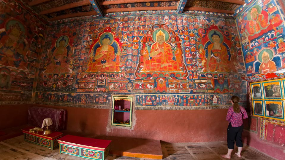
Sophie admires the mural at Basgo - Jamie
Day 1 - meet in Leh 3480m
Phew, after a long series of flights, you are here! Look for a Project Himalaya sign or a simple sign with your
name on it at the airport, and our wonderful drivers Ang Chuk or Pasang will pick you up.
Jamie meets you at the hotel on your arrival and we discuss altitude health over
tea/coffee or breakfast and introduce Leh (if you are a first timer) and show you the better places
to eat. Most people crash out for a few hours and spend the day relaxing; do drink
plenty of fluids which helps the acclimatization process, perhaps pop some vitamins and let your body adjust to the new time zone.
We normally go out to
dinner together, let's meet in the peaceful hotel garden at 6:30pm. We eat at some of our favourite clean (very important!) restaurants: Chopsticks, G Kitchen, Tibet Kitchen, Open Hand and Summer Harvest.
2 - Leh 3480m
This is a day for sightseeing. For today perhaps the best plan is to visit some of the world's most revered gompas and
monasteries a short distance from Leh. We will help plan and arrange a jeep, and a local
cultural guide if you like (included). Usually we arrange as a morning trip with lunch at Leh (or Thikse) then
you can relax in the afternoon although we can easily arrange a full day trip.
Choosing where to go is the biggest
challenge, there are so many special places to visit. To the east is Shey, Thikse, Hemis, Chemde, Thagthok, Stakna, Matho and Stok, although don't plan on visiting all of them in one day. Thikse also has a good restaurant for lunch.
Heading west out of Leh are Spituk, Phyang, Nyemo where the Indus meets the Zanskar River, and further afield are Basgo, Likir and Alchi.

3 - Leh 3480m
After gentle sightseeing yesterday we exercise a little more today. In the morning we wander up to the palace and gompa above Leh, and before dinner, perhaps up to the Peace/Shanti Stupa for a Leh
sunset panorama. Because tomorrow we stay 4000m, at minimum we need three nights here in Leh prior to moving
higher.
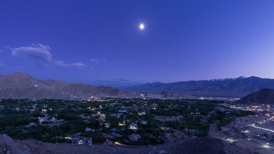
Leh under moonlight from Shanti Stupa - Jamie
4 - drive Lhatoo 4000m with sightseeing
Starting a trek in Ladakh always involves the altitude issue and we take acclimating seriously, and have vast experience helping people acclimate. For this trek we break the jump of 870m/2850ft between Leh and our trek start into two parts, spending the night at 4000m between, a proven formula. We have watched other groups ruin their treks with over-large altitude gains out of Leh.
It is only a couple of hours drive to our camp on the Leh-Manali road so we
visit some gompas that are further afield from Leh along the way such as Matho,
Stakna, busy Hemis or Chemre and Thag Thog. What haven't
you already seen?

Ang Chuk, one of our regular drivers, with his turbo Scorpio jeep - Jamie
We camp at Lhatoo with our trek crew, which is more
comfortable than the simple hotels there, and get our first taste of Phuntsok's
wonderful cooking.

The 2014 team camping en route to the trek start - Jamie
5 - drive Sangtha 4420m via Tanglang La ~5328m, trek Yabuk ~4340m
With more altitude under our pillow, we drive over the Tanglang La, claimed by India to be the second highest road
pass in the world, and regardless of the reality, it is scenic with views of the
Kang Yatze mountain range and over the other side, the More/Mare Plains. It is often windy and cold too...

A Tanglang La view - Jamie
We then slip off the main Leh-Manali highway to Sangtha, a deserted-in-summer nomad camp, which we reach around lunchtime.
There is one tricky stream crossing for the jeeps and we need good river conditions to be able to drive all the way, however if the river is slightly higher, we will start trekking a few kilometers earlier, which isn't a problem.
We trek a few hours in the afternoon to either Yabuk Gongma, our delightful 2014 camp, or its sister camp Yabuk Yogma a little further down, and introduce you to
our camping setup and relax in the peaceful area.
Few trekkers ever use this route and in 2014 our camp was visited by some younger Tibetan Argali sheep,
very rare to see. Above the camp was a lammergeier nest with a chick in it and pikas popped up all around our camp, so we really have jumped in to the wilderness.

Our delightful Yabuk Barma camp - Jamie
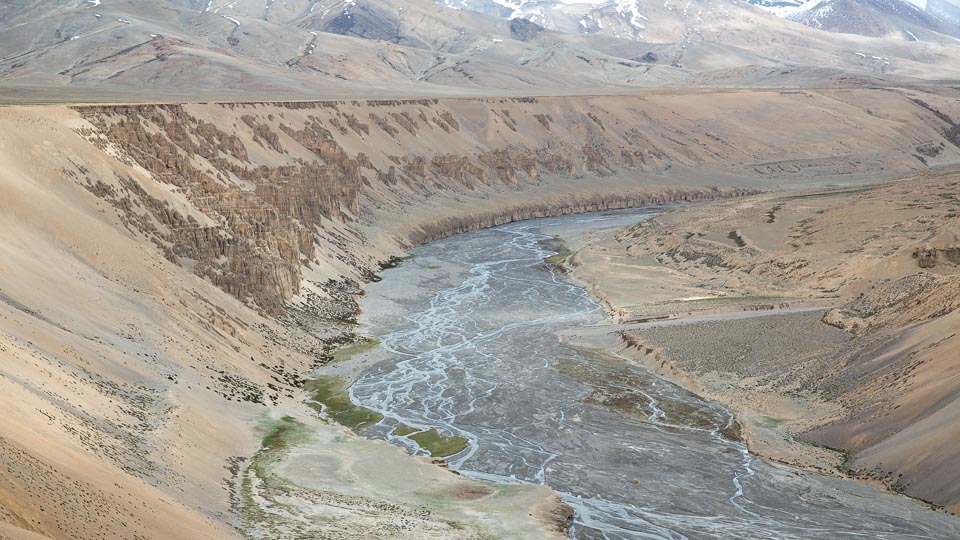
6 - trek Tozay Chu camp 4450m
We follow the champagne Zara Chu (chu is water and river in Tibetan) downriver until the stony junction with the Tozay Chu where
we turn upstream into the broad valley and wander along to one of the many possible grassy camps on the river bank.
Nights 5, 6 and 7 are all at ~4500m so we really can get used to the altitude, a real key
before progressing higher.

Trekking along the river is delightful as it is the warmest time of the year - Jamie
7 - trek Numa camp 4550m
We continue stram hopping along the pinnacle-sided river valley to the Leh-Manali highway, which we cross close to Pang, a startling contrast of "development" and the cleanliness of the wilderness. So we do cross the road; sadly there are fewer and fewer
treks that are not interrupted by a road, however this is also a chance to resupply. Soon after we also pass one of our favourite camps, our "yogurt" camp, full of memories from explorations of yesteryear and yesterdecade.
However rather than staying there we continue on to the next good camping area as this allows us to cross the pass tomorrow...
Our delightful Pang camp is one of the more distant green patches close to the
river - Jamie
8 - trek Lanyar 4850m via the Thelakung La 5020m
At last we trek above 5000m, briefly, crossing this pass that so many people get lost on. Don't follow the main valley to the end!
We are spoilt for camping choices in the huge valley, filled with yaks being herded by Tibetan cowboys in 2014, and often has nomad camps where we can get fresh yoghurt and perhaps even some dried meat. It is also kiang and wolf country and has gorgeous, oh so spacious panoramas.
Note Lanyar is located wrongly on the second edition of the Olizane (Swiss) map...

Local cowboys herding their yak - Jamie
9 - short trek to high camp ~5150-5350mm
Although we can stay at or near Lanyar we will probably ascend a couple of hours up this valley where last year Lobsang and Veronica saw a wolf. We then rest and wash, and if you have the energy perhaps explore. We are acclimatizing ready for our first seriously high pass tomorrow.

We will meet nomads somewhere - Jamie
10 - trek Sumdo 5250m via the Lanyar La 5860m
This is the real pass, not the one marked wrongly on the Olizane map, and is a stunner. The top of a pass filled with the expectation of new views, an opening towards where we are heading; at the same time, we are leaving where we have come from with some real finality.
We ascend the bump beside the pass for that 6000m feeling. Where we camp will depend on where we get to, there are a number of spots in this area so familiar to us.

En route to crossing the real Lanyar/Lanyak La - Jamie
11 - rest-explore Sumdo 5250m
Clothes washing and taking in this incredible valley system. We rest high, this is one of the highest valley campsites there is; and that means even some 6000m exploring won't necessarily be too tough.

Exploring above camp - Jamie
12 - trek Korzog Sumdo 4650m via pass 5600m and Yalung Nyau La 5430m
This high, broad area at last ends atop another pass, and we descend initially in a tighter valley to a good camp. Our cook, Punsok, is from this region and doubtless we will run into family today or tomorrow.
13 - trek Peldo (Tsomoriri nomads camp) 4560m
The reward is staying on the grassy flats at the head of
the lake, where nomads will almost certainly be camping, with their herds of
yaks, goats and sheep.

Even Getty liked this shot - copyright 2014 Jamie McGuinness
14 - trek Skyurchu 4850m
We camp near the sKyurchu spring (the "s" is light, the "K" is heavy) which
is the best camp for us as our previous delightful "flowers camp", Nima Kanchik,
has been taken over by army road workers.

Skyurchu camp and Tsomoriri, moon and stars, with the lights of
Korzog/Korzok and an army base - Jamie
15 - trek Base Camp 5680m via pass 5930m
I have to admit, the first time we crossed this pass I was seriously caught out, expecting to climb high a day later. When we climbed Lungser Kangri years ago we simply ascended up the valley floor from an utterly delightful camp, that is now a road worker's camp, so it sees a lot more use than previously.
Anyway, there is some real ascent today, and on a relatively skinny trail although as you can see in the photo below the terrain in moderate. After some descent down the other side, we suddenly arrive at our grassy base camp.

Crawling up the 5950m pass - Jamie
16 - rest Base Camp 5680m
Last night we slept higher than Kala Pattar in the Everest region or indeed
the top of Annapurna's Thorung La so have an extra day to acclimatize, all part
of maximizing our chance of success. It is a pleasant spot but there isn't a real view of the mountain yet, and neither down to the lake, however there are good views when exploring from the camp.

Lungser Kangri Base Camp - Jamie
17 - trek High Camp 6000m
Up we go and have a big jump in altitude today, that the previous
climb and long time we have spent at altitude assists us with.
Amazingly enough we can take the pony team to High Camp, which is only a
couple of hours from BC. We spend the afternoon preparing our gear for the climb tomorrow.

Arriving at high camp - Jamie
18 - climb Lungser Kangri 6666m
The big day and we start out a little after dawn (depending on weather) for the long
haul to the
summit. Initially we reach the 6200m col between Lungser and Chamser Kangri, and
occasionally groups camp here but the altitude jump first from Skyurchu and then
BC really is too extreme. The terrain is mostly easy although we do climb on snow, and one area
has a couple of crevasses, easily avoided or jumped over. It will
probably take us around 6-7 hours to the summit although the fit and
well-acclimatized make take less than 5 hours (as we did in 2014). The views are glorious over the lake
and on the opposite side, the the restricted Hanle area, where Lobsang is from.

2013 summit success (although no views from the summit this time);
we need a better photo, here is to summiting in 2015!- Jamie
19 - descend to Skyurchu
It will probably be a hot direct descent down the stony valley to a point
where we can meet the jeeps. It will also be our last camp overlooking this magnificent
lake.
20 - drive Leh
We hit the road, back to Leh with around 6-7 hours driving time (barring
delays) where we deserve a cold beer or cocktail and a celebratory
meal. Chopsticks or Bon Appetit?

Stakna Gompa, with this view we know we are getting close to Leh - Jamie
Day 21 - trip ends
You are free to take the morning flight to Delhi or bus to Manali for the
long way back, or just enjoy more time in this central Asian town of yore.
Julley!


