


Detailed itinerary
Note that although we try to follow the itinerary below, at times local trail or weather conditions may make slight changes necessary. The trekking itinerary may also vary slightly depending on our trekkers' acclimatization rates.
Early Arrival
Providing you have sent us your arrival details, you will be met at the airport by a representative from the Kathmandu Guest House (look for their sign - they will be looking for you) and escorted to the guest house. Kim will book the extra nights for you, so your room will be ready.
Day 1 - Arrive Kathmandu 1340m
You'll be met at the airport by a representative from the Kathmandu Guest House, so look out for a Kathmandu guest house sign when you leave the airport. They will bring you back to the Kathmandu Guest House, where your rooms are booked.
Kim will meet you at the guest house and introduce you to Thamel, the main tourist area of Kathmandu. Thamel is a myriad of banners, signs, music shops, bakeries, internet cafes, restaurants, bars, hotels, shops of all imaginable varieties and eccentrically clad backpackers. Over dinner we check your insurance details (please have a copy of your travel medical insurance policy with you), go over gear and get to know each other over a beer at New Orleans cafe ...

Day 2 - Kathmandu
A free day to explore exotic Kathmandu and the mythical Kathmandu valley. Options: Climb the many steps to Swayambhunath (the monkey temple), with its commanding views of Kathmandu (at 1420 meters), its whitewashed stupas and its unique synthesis of Buddhism and Hinduism. The striking Buddha eyes of Boudhanath Stupa watch over a lively and colorful Tibetan community and attract pilgrims from all over the Himalayan Buddhist realm. In the midst of traditional gompas, and hung with long strings of multi-colored prayer flags, Boudhanath attracts Sherpas, Tibetans and tourists alike for daily circumambulations (koras) of the stupa. Durbar Square, one of the old capitals of the Kathmandu valley, is a synthesis of Hindu and Buddhist temples, stupas and statues, and is often the site of festivals, marriages and other ceremonies. Hindu Pashupatinath and its sacred temple complex on the banks of the holy Bagmati river. Here, monkeys run up and down the steps of the burning ghats, and trident-bearing saddhus draped in burnt-orange and saffron sit serenely meditating - when they’re not posing for photos-for-rupees.
We'll have time for a bit of gear shopping in Thamel for anyone who needs to do this, and in the evening will head out for dinner - perhaps a few cold beers and a wood-oven pizza at the Roadhouse Cafe ...
Day 3 - Fly Pokhara 800m
Up early for our short but scenic flight to Pokhara, 198 kilometers west of Kathmandu. You will fly high above the north-south rivers flowing down towards the Terai from the Himalaya and Tibet, over terraced villages and green hills with the Ganesh, Langtang, Manaslu and Annapurna ranges in the distance, to balmy, sub-tropical Pokhara. We stay at the fantastic Barahi Hotel, it's clear pool a wonderful oasis in the afternoon heat. We have the afternoon to wander the shore of Phewa Lake, drink fresh juice, do some shopping, or sit and relax at the hotel with a book. Head to Moondance Cafe for dinner and drinks in the evening, an atmospheric restaurant just near the hotel.

Day 4 - Fly Jomsom 2720m. Trek Kagbeni 2900m
Up early for our spectacular mountain flight to the district headquarters of Mustang, Jomsom. Once on the ground, at 2720 meters, we are greeted by the sound of jingling horse bells as the Mustangi people pass by with their pony caravans. After sorting out gear and loading our porters, we trek up the windy Kali Gandaki valley to Kagbeni. Another early breakfast after which we head to the Pokhara Airport for our spectacular mountain flight to the district headquarters of Mustang, Jomsom. From the airport we have a fantastic panorama of Himalayan peaks: to the far west, Dhaulagiri, followed by Annapurna South, Hiun Chuli with Annapurna I in back, the sacred Machhapuchhre (Fishtail), Annapurna III, Annapurna IV, Annapurna II, Lamjung Himal, Himlung Himal and perhaps, on a clear day, Manaslu, Peak 29, Himal Chuli, Boudha Himal and Ganesh Himal to the distance to the far east.
Once on the ground in Jomsom at 2720 meters, we are greeted by the sound of jingling horse bells as the Mustangi people pass by with their pony caravans. After sorting out gear and loading our porters, we trek up the windy Kali Gandaki valley to Kagbeni. The wide trail along a sandy, saligram-filled riverbed provides views of the surrounding peaks of Dhaulagiri, Tukuche and Niligiri, and to the south the entire Annapurna Massif. Kagbeni, spectacularly situated atop a cliff overlooking the confluence of the Kali Gandaki and the Jhong Khola rivers, is the last village in Lower Mustang and guards the entrance into Upper Mustang, visible across the Kali Gandaki riverbed. It is an oasis of green, patchwork fields in the midst of rocky, arid mountains, with Niligiri looming grandly behind it. This ancient, partially ruined citadel town provides us with a taste of scenes to come in upper Mustang, with its narrow alleyways and tunnels, irrigation canals, green fields of barley and its massive, newly-restored brick-red Sayka gompa, 800 years old. We'll also wander past the ancient, crumbing, 100-room King's Palace. At the police check post at the north end of the village where a sign reads 'Restricted area, tourists please do not go beyond this point', we will complete our paperwork to enter Upper Mustang tomorrow. We'll stay at the New Annapurnas Lodge for the night, with time to explore the village. Enjoy the fantastic views down-valley to Niligiri in the late afternoon, the alpenglow coloring it a lovely pink hue ...

The wide trail along a sandy, saligram-filled riverbed provides views of the surrounding peaks of Dhaulagiri, Tukuche and Nilgiri, and to the south the entire Annapurna Massif. Kagbeni, spectacularly situated atop a cliff overlooking the confluence of the Kali Gandaki and the Jhong Khola rivers, is the last village in Lower Mustang and guards the entrance into Upper Mustang, visible across the Kali Gandaki riverbed. It is an oasis of green, patchwork fields in the midst of rocky, arid mountains, with Niligiri looming grandly behind it. This ancient, partially ruined citadel town provides us with a taste of scenes to come in upper Mustang, with its narrow alleyways and tunnels, irrigation canals, green fields of barley and its massive, newly-restored brick-red Sayka gompa, 800 years old. We'll also wander past the ancient, crumbing, 100-room King's Palace. At the police check post at the north end of the village where a sign reads 'Restricted area, tourists please do not go beyond this point', we will complete our paperwork to enter Upper Mustang tomorrow. We'll stay at the New Annapurnas Lodge for the night, with time to explore the village. Fantastic views down-valley to Niligiri.
Day 5 - Trek to Chhusang 2955m
After breakfast, we enter the restricted area of Upper Mustang with our staff and horse caravan in tow. We head high up a trail of scree to a ridge crest, which affords us wonderful views of the patchwork of Kagbeni and Niligiri down the valley. We continue trekking on the east bank of the Kali Gandaki along the new road, high up on the plateaus above the river-bed, all the time with magnificent views from all sides. The village of Tiri Gaon sits on the west bank of the river. We head north past the red, white and black chortens to the fortress-like Gurung village of Tangbe (3030m) three hours past Kagbeni. Tangbe is a labyrinth of narrow alleyways separating white-washed houses, fields of buckwheat, barley, wheat and apple orchards, unique in Mustang with its moat-like drainage system. Tangbe is split into two sections, the ruins of its ancient dzong (fortress) in the upper section. Nilgiri, which dominates the southern skyline at Kagbeni, continues to loom massively at the foot of the valley.
An hour and a half past Tangbe we reach Chhusang village (2950m) where we set up camp for the night at the far end of the village in the walled orchard and campsite of a local teahouse. There is a salt mine two hours from Chhusang, and fortified Tetang village just up the same valley; the salt trade was of utmost importance to Mustang in years past, and much of the wealth of the villages came from this trade. Across the Kali Gandaki , high up in the dramatic, fluted rock face, are clusters of ancient caves, their origins lost in antiquity. We'll get you set up in your Mountain Hardwear and Big Agnes tents, set up Kamzang-style dining tent and introduce you to our camp routine. Chai is brewing, and we'll have our first cups of hot tea as we watch the village life unfold around us.

Note the extensive number of caves in the massive rock face across the Kali Gandaki. Of these caves, the historian Gucci believes that they were the homes of the earliest Lo-pas, later used by hermit-monks as retreats. (As Tibetans in the western part of Tibet lived in similar caves until recently). Many anthropologists believe that the caves were the Neolithic sites of early man from a time when there was much more water, large forests and plentiful game to hunt.
The culture from Tsaile north becomes more Tibetan; sheep horns adorn the houses, and there are protective amulets in the shape of a cross on the walls of the houses, similar to what we find in the old Tibetan villages in Ladakh and Zanskar. These 'zor' do what the look like they might do, capture evil spirits in their web and protect the inhabitants of the household, and date from the pre-Buddhist Bon religion. You will also see woman wearing the Tibetan decorative turquoise, coral and amber as well as 'dzis', ancient protective amulets of agate, which Mustangis believe came from lightening when it falls onto the mountains.
Day 6 - Trek to Samar 3605m
After a good breakfast and freshly brewed coffee we head off further into Mustang. Across the Narsing Khola, crossed by rock-hopping, is the northern part of Chhusang, which we wind our way through, passing the archery field at the end of the village. We head down to the rocky Kali Gandaki River bed where we might find saligrams from the Jurassic period (160 million years old) which were embedded in sediment of the sea floor. We soon cross the river on log bridges to the trail leading to Tsaile at 3060 meters, which looms high above us on the plateau. There is a famous bridge crossing the Kali Gandaki at a naturally-formed tunnel through which the Kali Gandaki flows. It's a very steep climb up a rocky gully to Tsaile, a lively village with several guest houses and extensive wheat and barley fields. We'll have a rest in the village and then start our ascent to Samar. The scenery is awesome, the classic high altitude desert of the Tibetan high plateau, and in back of us a chain of Himalayan peaks: Thorung Peak, Khatung Kang, Kangsar Kang, Annapurna l, Tilicho & North Tilicho Peaks and the Niligiri Peaks. Our trail continues to ascend as we trek past the river valleys leading into the Kali Gandaki River. Soon we reach a spectacular, steep canyon-side trail leading north into Upper Mustang. Across the canyon, there is a new suspension bridge to access the remote village of Ghyakar. The Dajori La, at 3600 meters, is marked by rock cairns, a 2 1/2 - 3 hour trek from Tsaile.
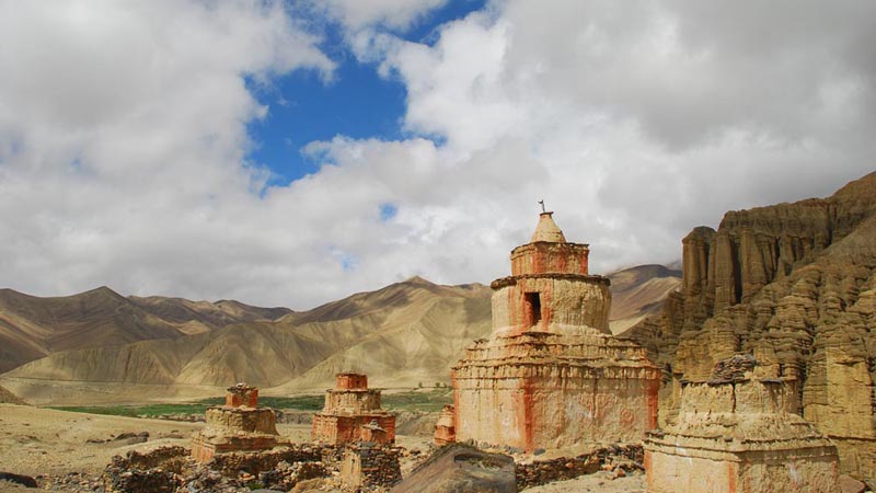
Lovely Samar is visible just below us, and we traverse to a group of chortens on the ridge above the village, soon after reaching the green village of Samar (3605m), with its lovely poplar grove and flat-roofed houses, formerly a staging post for Khampa raids into Tibet. The Annapurna range, still dominated by Nilgiri, is visible to the south, a fantastic backdrop. We'll set up camp on the green grounds of the New Annapurna Guest House, one of our favorite campsites and the owned by good friends. Showers are available inside the lodge and feel free to go into the kitchen for a cup of tea ...

After a good breakfast and freshly brewed coffee, we hit the trail, ascending steeply to a ridge above Tsaile. The scenery is awesome, the classic high altitude desert of the Tibetan high plateau, and in back of us a chain of Himalayan peaks: Thorung Peak, Khatung Kang, Kangsar Kang, Annapurna l, Tilicho & North Tilicho Peaks and the Niligiri Peaks. Our trail continues to ascend as we trek past the river valleys leading into the Kali Gandaki River. Soon we reach a spectacular, steep canyon-side trail leading north into Upper Mustang. Across the canyon, there is a new suspension bridge to access the remote village of Ghyakar. The Dajori La, at 3600 meters, is marked by rock cairns, a 2 1/2 - 3 hour trek from Tsaile.
Lovely Samar is visible just below us, and we traverse to a group of chortens on the ridge above the village, soon after reaching the green village of Samar (3605m), with its lovely poplar grove and flat-roofed houses, formerly a staging post for Khampa raids into Tibet. The Annapurna range, still dominated by Nilgiri, is visible to the south, a fantastic backdrop. Passing through Samar, we go through the entrance and exit 'kane' chorten and descend steeply on a switch-back trail to the Samarkyung Khola where we soon take the left fork, climb steeply on stone steps to a view-point. After a short rest, we continue to climb another half hour to the chorten-topped Bhena La (3840m). We continue past the seasonal Bhena village along a lovely, high, wooded trail with wonderful, broad vistas across the canyons, climbing sharply up to the Beg La, just a ridge, and past the two-house seasonal village of Yamda. After an unrelenting gradual ascent, we finally reach the Yamda La (3985m) , adorned with a large cairn and a tangle of multi-colored Tibetan prayer flags, called 'lung ta' or wind horses. The views from the top are spectacular, so we'll stop for a bit to enjoy them.
A steep switch-back cutting down through the new, dirt road leads to the small hamlet of Shyangboche (3765m), originally a seasonal kharka, named after the a girl, Shyangbo (che means place in Tibetan). Shyangboche has three basic lodges, and the staff will have set up camp for the night in the grassy campsite of either the Dhaulagiri or the Niligiri Lodge.

Day 7 - Trek to Zaite 3840m
Passing through the village of Samar, we go through the entrance and exit 'kane' chorten and descend steeply on a switch-back trail to the Samarkyung Khola where we soon take the left fork, climb steeply on stone steps to a view-point. After a short rest, we continue to climb another half hour to the chorten-topped Bhena La (3840m). We continue past the seasonal Bhena village along a lovely, high, wooded trail with wonderful, broad vistas across the canyons, climbing sharply up to the Beg La, just a ridge, and past the two-house seasonal village of Yamda. After an unrelenting gradual ascent, we finally reach the Yamda La (3985m) , adorned with a large cairn and a tangle of multi-colored Tibetan prayer flags, called 'lung ta' or wind horses. The views from the top are spectacular, so we'll stop for a bit to enjoy them. A steep switch-back cutting down through the new, dirt road leads to the small hamlet of Shyangboche (3765m), originally a seasonal kharka, named after the a girl, Shyangbo (che means place in Tibetan). Shyangboche has three basic lodges; we'll stop for lunch in one of them.
From the lodge we have a short climb to the Shyangboche La, just 50 meters above the village, where the trail intersects a wide east-west valley. There are fantastic Himalayan panoramas from the crest, and we look down to the east to the picturesque village of Geling. Above Geling is an old, brick-red gompa and ancient meditation caves in the eroded cliffs, and in the village a new school and white-washed Mustangi houses surrounded by barley fields. We trek north on the new road, cutting down to a smaller trail which leads over a small stream. We climb to the small hamlet of Tamagaon (3700m) and continue along a lovely trail amongst rounded granite boulders to the small hamlets of Chhunggar (3750m), where there is a large, colorfully striped chorten at each end of the village. On to another small hamlet called Zaite (3820m), from where our trail intersects the trail and dirt road leading up from Geling. We'll set up camp in a green campsite with views on the upper end of Zaite, another fantastic spot.

Day 8 - Trek to Dhakmar 3820m
After a scenic breakfast we head further up the trail and dirt road to the Nyi La (4000m), just a half hour climb from the intersection. More of Upper Mustang opens up in front of us a the cairn-topped pass, including the new road snaking its way to Tibet. We descend on the road for a bit, but soon head off on a small trail and continue contouring around hillsides to the Ghemi La where there are wonderful views down to the checkered fields and large, beautiful village of Ghemi (3570m).
We descend steeply down to Ghemi, built along the steep edges of the cliff as are many fortified villages in Mustang. There are actually the ruins of an old fortress somewhere in Ghemi, which was largely abandoned until the Khampa fighters set up a magar (war camp) here and brought new life and wealth to the village. We'll wander a bit through this interesting village, passing the mani walls and prayer wheels, perhaps finding the key-keeper to open the Ghemi Gompa for us. Afterwards, we take a small, rocky trail down to a bridge crossing the Tangmar Chu and stop for lunch on the grassy banks of the river. Revived, we cross the bridge and climb a steep, dusty hill. The trail looks across the valley to ochre, blue and steel-grey cliffs, and leads us past tri-colored chortens and perhaps the longest and most spectacular mani wall in Mustang, behind which is the hospital. Looming ahead of us is a cluster of gigantic, ancient chortens, backed by dramatic, sculpted cliff-faces, an awesome sight. We continue hiking through a scenic, green valley, stopping occasionally for passing herds of sheep and goats, soon arriving at the lively, sprawling village of Dhakmar, dominated by a dramatic, red canyon wall with many ancient cave dwellings. Following the small stream through the lower part of the village, green with old willows and more recently planted poplars, we set up camp for the night in the courtyard of Tenzin Riverside Guesthouse, another wonderful trekking day. Across the stream on the western side is an old gompa. Sunsets against the red cliffs, which house Himalayan Griffins and Lammergeyers, are fantastic ...

Day 9 - Trek to Nomad Camp 4280m
One of our best trekking days is in front of us as we head towards the green nomadic plateau to the east of Lo Manthang. More dwellings and green pastureland ahead of us as we head slowly up valley to the prayer flags at the end of the village, 20 minutes from camp, and start to climb steeply through the canyon and spires. We reach a narrow ridge, and stop for a rest, looking out at the Himalayan peaks in the distance. Blue sheep graze in these arid hillsides, their tracks stripping the otherworldly ridges, and Griffins and Choughs soar in the clear, blue Mustangi skies overhead. It won't take long to pass through the narrow opening in the cliffs and cross first ridge of the Mui La (4175m). Climb the small hill to the left of the cairn; the views down the Dhakmar Valley are breath-taking, as is the sight of our horses cresting the tunnel-like pass. We drop back down and the climb yet again through high meadows by a meandering, rocky stream to the other Mui La (4130m). Finally, Lo Ghekar, 'Pure Virtue of Joy', set majestically in the valley below us. Ghar Gompa, built in the 8th century, is one of the oldest gompas in Nepal. It belongs to the Nyimgmapa sect and is connected by legend to Samye Gompa in Tibet as well as to the ubiquitous Guru Rimpoche. The name means 'house gompa' after the style of architecture, and harbors many exemplary frescoes as well as wonderfully carved and painted mani stones. Surrounding the gompa are massive, block-like chortens of a unique style and strings of colorful prayer flags fluttering in the winds of Mustang.
Lo Gekar: Samye Gompa, the oldest gompa in Tibet, was repeatedly destroyed by demons when it was being built. The head lama dreamed that Guru Rimpoche could help with the construction and invited him to the site. The great Guru Rimpoche found demons to be the problem, and suggested that they first build Lo Gekar. Guru Rimpoche killed the demons at the spot that Lo Gekar was soon to be constructed. The long mani wall just south of Dhakmar is said to have arisen from the intestines of the demon, and the red cliffs above Dhakmar the blood of the demon. After Lo Gekar was completed, Samye in eastern Tibet was also successfully built.

After a look at the 'lha-khangs' or prayer rooms of the gompa, we have a big climb to our next pass. We head east from the gompa, descend to the Tsarang Khola which we cross on a wooden bridge, and then ascend first steeply and then contouring, and more gradually, for 1 1/2 hours to a pass west of the Marang La that we have named Nomad Pass (4305m). From the pass, a pole with a prayer flag is visible to the west, marking the hill above the nomadic settlement. After a break at the pass, we hike for twenty minutes across green, tundra-like hills to the crest overlooking our campsite, East Nomad Camp. We have a bird-eye view over this scenic valley, dotted with nomadic tents of yak-hair, yaks, herds of sheep and goats, piles of yak dung and nomads. Two families live in this valley, and two more in the valley over the next ridge. Our campsite is idyllic, set right next to a clear stream on a grassy, flat plateau looking down-valley over Himalayan peaks. We'll visit the lively doksa later in the afternoon, perhaps being invited for a steaming cup of salt-butter tea and dried cheese. This is one of the last nomadic settlements in all of Nepal, a rare chance to see how real Tibetan nomads exist. We are quite high so it gets COLD in the evening. Sunsets and sunrises are perfect.
AFTERNOON TRIP: Hike over the hill to visit the other nomadic settlements in the afternoon; all of the nomads were living in the Tibetan borderlands northeast of Lo Manthang, but many families moved to this spot about fifteen years ago to have better access to supplies, schools and medical facilities in Lo Manthang. From the hill between the camps, at the prayer flag, you can look right down to the walled city of Lo Manthang, a great view. Locals from Lo Manthang might come to the doksas to collect the sheep and goat dung that the nomads don't use. We might get some yogurt from the nomads, delicious and fresh, and we can buy exquisite textiles from the nomads if we like.

Day 10 - Trek to Lo Manthang 3820m
Still chilly, we leave camp in our warm jackets and climb again to the hill above camp, dropping down into the other valley below the nomad camps that we visited yesterday. We hike for a few hours following the valley bed, past the ruins of ancient fortresses and gompas, and soon see the walls of Lo Manthang, aptly named the ‘Plain of Aspiration', ahead of us. Horses roam freely amongst the the crumbling walls and fields. We trek along the southern walls surrounding the city and reach the small bridge also accessed from the Lo La and the road from Tsarang.
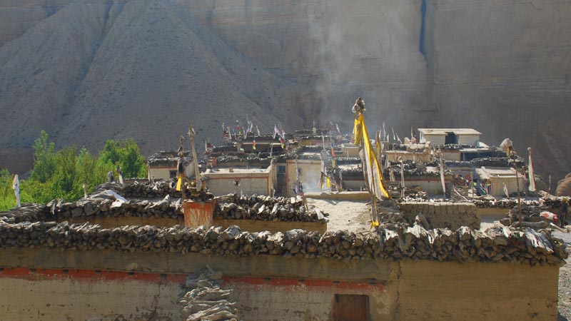
We have reached the fabled walled city of Lo, with a single entrance through which only the King, Queen and Kempo (Abbot) are allowed to ride. All others must walk, to pay their respects to Chenrizig, the Buddha of Compassion. King Jigme Palbar Bista, called 'Lo Gyelbu' by the Mustangis, still resides at his four-storied palace inside the city walls; that is, when he’s not in Kathmandu. He is an avid horseman, and keeps his own stable of horses, some of the best in Mustang. These days, the king plays a somewhat ceremonial role although he is well loved and respected throughout Mustang. The present king is the 25th descendent of Ame Pal.
We enter the outer walls of the city and head to Pema Bista's campsite right at the walls to the city, under a small grove of ancient, sacred willows. The horses and crew will arrive behind us, so we will start exploring the maze-like alleyways of this fascinating village. Be prepared for the onslaught of tourism in Lo as vendors immediately find us and set up 'shop' next to the campsite. It's not as pristine as it used to be, but just as mystical in the golden, yellow light as the local men bring their sheep and horses inside the city gates for the night. Perhaps, we we'll have a cup of the infamous suija (salt butter tea) at Pema's house in the afternoon, after visiting his shop. And we'll have plenty of time to marvel at the surrounding panoramic views of the Tibetan Plateau and the Himalayan peaks bordering Tibet.

Lo Manthang:
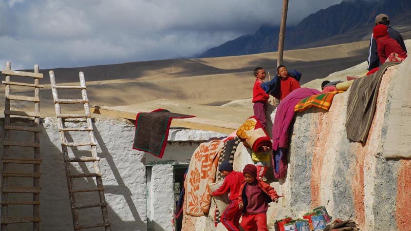
There are four major temples within the medieval walls of Lo, the 14th century, brick-red Jampa Lhakhang (the oldest gompa, built in 1387, with the striking 50 foot 'Jampa' (Future) Buddha, the largest clay statue in Nepal until a few years ago), 15th century Thubchen Gompa (Great Assembly hall, pillars 30 feet high, the second oldest gompa with fantastic murals in the Dukhang), Chhoede Gompa (where the Kempo lives, with a monastic school) and Choprang Gompa. There is also the Raja's Palace, home to the present King Raja Jigme and Queen 'Rani Sahib' (who is from an aristocratic Lhasa family) and an interesting maze of a village to explore. There are approximately 1100 Lobas and 180 houses within the walls of the city although many lower caste Lobas live outside the walls. Many of the Lobas still practice polyandry.
In the 1380’s, King Ame Pal established his reign in Lo, with the walled city of Lo Manthang as the capital and its inhabitants called Lobas. Within the walls of Lo Manthang are about 150 houses built among narrow streets, and some of the largest and finest Tibetan Buddhist gompas in Nepal. The city is quite prosperous due primarily to its past salt and wool trade along the Kali Gandaki with Tibet, and the Lobas themselves are still very Tibetan, living in Tibetan-style dwellings which we'll have a chance to visit. There are even yeti (known here as mehti) prints rumored to be found.

Day 12 - Lo Manthang – Visit the Chosar & Tingkar Valleys
*** We recommend horses for anyone wanting to come along on this day-trip; others are free to stay and wander the intriguing streets of Lo. There is an amchi that runs a Tibetan herbal medicine clinic in town, two schools and even a coffee shop along with the increasing number of shops to visit.
Leaving Lo along a wide, canyon trail, past dry gullies and an ancient, ruined fortress, across a bridge and through a cultivated area, we finally view the cave village of Chosar, with the deep-red Nyphu Gompa built into the rock face. We'll need to cross two bridges to arrive at the gompa, at 3760 meters. Plenty of time for photographs before rounding the chorten-toped bend, where we get views of Gharphu Gompa on the east banks of the Mustang Khola. Past the gompa is an incredible cave-dwelling site called Jhong Cave, which you negotiate by ladders and through small tunnels, very interesting and reputed to be 2500 years old. In front of us, a range of spectacular snow-peaks marks the border with Tibet, and around us gurgling streams and green meadows line our trail. If we take the long loop, we can stop at Nyamdo Gompa, ride over a small pass and then head back down the western valley to Lo.
The western valley leads to Namgyal Gompa (the Monastery of Victory), set spectacularly on top of a desolate ridge and the newest and most active gompa in Lo. The village of Namgyal spreads out past the Gompa. Just past the gompa is the large, sprawling village of Tingkar, where the King has his summer palace. There is a new gompa here, where we saw a puja (prayer ceremony) last year, and met most of the villagers! There are also many ancient ruins surrounding the village, some gompas and others old fortresses perhaps. Further on, we reach Kimaling village, which is an interesting, white-washed village surrounded by fields where we did some carpet shopping last year. Kimaling Gompa is below the village, on the way out as we head towards Phuwa and its gompa on the way down towards Lo. There are tremendous views of Namgyal Gompa backed by snow-peaks behind us as we wander up the valley, and white peaks in front of us bordering Tibet.
The Chosar valley was the main trading route with Tibet and Lhasa, and is peppered with the ruins of old fortresses guarding this strategic valley. Just north of this valley, over the border in Tibet, Lhakpa and I met a Tibetan man who still dealt in the trade of rare animal skins with Mustangi traders, a risky and of forbidden endeavor. It will be interesting to see if we can find out anything of this trade on the Nepal side of the border.
Back at camp, dinner is on the fire, tea is brewing, and cold beers are available from the tea-shops, so relax and enjoy our last evening in this magical capital.

Day 12 - Trek to Chos Sung Plateau 3850m
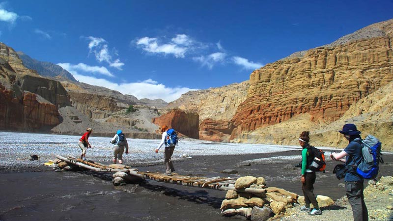
A river day, bring your sandals. Sadly, we must leave magical Lo, but new adventures await us on our rarely visited route southeast. Back out the gates of Lo, we head directly east, or to the left, following the gurgling, willow-shaded Dokpolo Khola for about an hour. This is an wonderfully green section, with grassy river banks underfoot, stone walls bordering the river, and behind, backed by the snow-peaks bordering Tibet, the ruins of the once-imposing Lo Dzong. At the intersection of the Nhichung Khola, we head south at Namaru Dikha kharka, trekking on sun-baked plateaus and down stone steps, crossing the river a few times. There are hot springs just below our trail, not very hot but worth sticking feet into. To our left, high in the rock face across the river, is an incredible complex of caves gompas, only explored a few years previously by an international research and climbing expedition. There are several other caves built into the cliffs along today's trail, testament to an ancient cave-dwelling civilization and the monks that later used them as meditation retreats. Further along the clear river past the mustard-stained Tumu Khola intersecting our river from the left, we take a sharp left into the narrow canyon of the Chhuchhu Gompa Khola, which soon widens into a large, pebbly flood plain. At this sumdo the rivers become the Kali Gandaki river as it heads almost directly south. We will have to cross the tangle of streams several times during this section, so best to hike in your sandals for the next hour.

At the next intersection, still staying left, we take a bridge high over the river, possibly having to unload the horses in the narrow, high section just after the small bridge. The canyon narrowing around us as we hike. We've entered a lost world of contorted canyons, muted earth-tones and narrowing passages, the wonderful world of 'lost' Mustang. More mustard and blood-orange stained rocks signify mineral content in the organically-shaped rock, and we start to see salt drips suspended from the rock faces, intriguing hints to past salt trade in the region which made Mustang wealthy. We'll be crossing the river continuously and it can get quite deep, so be ready with good sandals. Soon we reach another river intersection. The left fork heads to the 14th-15th century Chos Sung Gompa which Peter Mattheissen wrote about in his book, 'East of Lo Monthang' and which houses some of the most important Buddhist artwork in Mustang. Unfortunately the main cave entrance has now crumbled away and is inaccessible. The nomads to the north hold the key to the main gompa.
After approximately half an hour of jumping the snaking river along the flood plain, we suddenly ascend dramatically, climbing on a steep trail of loose scree to a ridge which affords us incredible views up and down the valley. Soon afterwards we crest a small pass with an dramatic chorten and are treated to the dramatic site of the 14th - 15th century Chos Sung Gompa (Chuchu Gompa) nearly at our level in the cliff-side ahead of us. Chos Sung translates as 'books' 'listen to' after the tradition of taking the books out of the gompa, walking them in a 'kora', and reading them to the nomads or villagers who would come for the readings .
We'll spot our horses unloading below, and the staff setting up our campsite in this idyllic spot, not a Westerner in sight. Welcome to Matheissen's hidden Mustang. Have a quick scramble up to Chos Sung Gompa if you have the energy, and marvel at the exquisite artwork adorning the crumbling walls. The main gompa has a lock on the door which the nomads will open for us in three days, but you can hike up to a smaller gompa in back of the main one, probably unlocked. Notice the tangle of antlers on top of the gompa roof, and the tsatsas in several of the caves. There is also an odd 'baby yak', stuffed, in one of the caves, but only some of our intrepid staff will be able to reach this dangerously situated cave. In the back of the cliff, now crumbling and inaccessible, is some of the most important artwork in the Tibetan Buddhist world. Unfortunately we won't be able to see it, but an Italian architect is making a book of the murals from this cave, perhaps the only ones that will ever be taken.

Day 13 - Trek to Nomad Mesa Camp 4785m
Another remote route today as we head high up to the plateaus near the border of Tibet to visit some of the last nomadic families in Mustang, still existing in their traditional Tibetan tents, herding their yaks and tending their Pashmina goats and sheep. It is interesting to contrast how these nomads live as compared to their neighbors in Tibet and Ladakh ....
We leave camp heading in the same direction as yesterday, following a long, ancient mani wall painted in red and many large chortens, all signifying the importance that this gompa enjoyed in years past. More caves, and an old mill site at the intersection to a small mill further indicate an importance now hard to imagine. Quickly we start to climb, and climb. As we ascend some of the world's largest peaks come into view: Dhaulagiri, Niligiri, Thorung & Tilicho Peaks, Annapurna 1 and other 7000 and 8000 meter peaks rise impressively in back of us when we finally reach the top of the windy nomadic plateau.
Camp is half and hour away, but we can hike first to the nomadic settlements just north of camp first if we decide. Our campsite is the one pictured in Peter Matheissen's book 'East of Lo Manthang', with nomads and their yak-haired tents backed by a towering Dhaulagiri, a fantastic spot. A prayer wall protects us from the north, and the border of Tibet is just an hour's walk away (or so we've heard).
Day 14 - Nomad Mesa Camp
A free day to explore, climb to the border of Tibet and/or visit with the nomads at their settlement which they call Tiblung, situated at 4960 meters. We had salt butter tea with in the Spring, and bought some of their beautiful textiles. The father's name is Sonam Nurbu, and he has a slew of children, in-laws and grandchildren livening up the one-room house. (They do actually have a basic house in this one spot as they have stayed here for so many years. Other nomads have traditional yak-hair tents, as they do in their other settlements). Sunset is unreal, have your camera ready ...
Day 15 - Trek Canyon Camp 3690m
We retrace our steps back to the Chuchu Khola campsite with a nomad who we hope has the key to the gompa and have a look at the murals housed inside this remote gompa. Back at the next intersection that we reached three days ago on the way in, we take the right fork and hike for another ten minutes to our rocky Canyon Camp right on the riverbank, next to the only willow tree in the canyon ...

Day 16 - Trek to Ghara
We have a hard, six or seven hour day in front of us so have plenty of fresh coffee and a good breakfast before we head off. We head along the pebbly riverbed, jumping the small Chaka Khola as we go. Half an hour after leaving camp we start a strenuous, steep climb to the top of the right-hand ridge, a 500 meter ascent to 4270 meters. After lunch we'll have another three hours of scenic contouring interspersed with a bit of climbing until we reach the crest of the last ridge that overlooks the Luri Gompa valley. Well before this last ridge (three ridges before, to be exact), we look down onto a large, lovely doksa of many stone enclosures with a green stream running through them at the valley bottom. On the map, this is called Kepuchhimi; we drop down to the doksa extremely steeply to on a trail of hardened mud, a difficult descent. We climb again and continue to contour with expansive views, waiting for the views of Yara and Ghara far below. Finally, weary after a long day, we reach a sharp, cairn-topped crest from which we spot the green oasis of Ghara village with its ruined gompa and old, winding walls below us, and Yara with its terraced, green fields of barley to the west. A welcome site.
Heading down, we soon see the red and white stripes of the fabled Luri Gompa below us, to the right of Ghara village. We keep to the right, descending steeply for an hour, and finally reach the wonderful. lively village of Ghara where the staff have set up our camp just above the village, in a walled enclosure with the village tap just below. We'll have many villagers as visitors, both adults and kids, all of whom will bring some of their ubiquitous saligrams and Mustangi artifacts to display ... Fantastic mountain panoramas down-valley towards the Kali Gandaki at sunset and sunrise.

Day 17 - Trek to Yara 3610m. Visit Luri Gompa
After breakfast we have a walk of less than an hour to the fabled Druk-pa Luri Gompa and its complex of Tibetan Buddhist caves, some of which are accessible others now 'closed' forever. One of the older Kings of Lo married a Bhutanese princess, thus the Druk-pa influence. The main Luri Gompa is situated down near the riverbed; the teacher, kids in tow, will lead on a crumbling trail us up to the upper prayer-room and the fifteenth century 'Kabum Stupa', made of highly polished stucco and painted with intricately detailed Newari-styled Buddhist frescos of the Kagyupa saints Tilopa, Naropa and Marpa. Historians estimate them to be from the 13th or 14th century, and linked to the Tashi Kumbum caves, one of a group of connected cave dwellings throughout this particular region. Unfortunately, or fortunately, most have been rendered inaccessible due to the intense erosion in Mustang, so will remain hidden throughout history.
After exploring the Luri complex, we drop back down to the riverbed and hike down-river towards Yara. An hour or so later we reach the access point to the Tashi Kumbum cave complex, accessible via a narrow ledge of a trail. Tashi Kumbum is a newly discovered group of six cave dwellings dating from the 15th century, with fantastic Buddhist murals and a large exquisitely painted chorten. Gary McCue, who went there over fifteen years ago, wrote that the approach is very difficult/dangerous although though only an hour from Yara. We discovered last year that our lodge owner was actually the one who discovered the ancient Tashi Kumbum, and then went there with Gary McCue. Exiting stuff and really one of the most amazing works of Buddhist art I have ever seen. Near Yara, to the left of the river, are fantastic, sculpted canyons with the remains of a network of ancient caves, now eroded enough to be inaccessible. Yara is an hour down the saligram-filled riverbed from Tashi Kabum. We camp for the night in the courtyard of a local guest-house in the lower section of town, a bustling campsite full of Mustangi life. Have a walk above the village in the afternoon, lovely with the sun shining through the willow leaves which brighten the village.

Day 18- Trek to Tsarang 3575m
Leaving Yara with the sculpted canyons shimmering in the morning light above the fields of barley, we pass the tri-colored chortens representing the past, present and future Buddhas and drop down to the river. We trek along the river valley, past the incredible fluted cliffs embedded with caves, narrowing as we get closer to the Kali Gandaki. The village of Dhi is to the right, just off our trail. Dhi was a major trading center of times past, and some of the wealthiest merchants had homes there. We pass above the tiny Surkhang village to the right of the valley as we climb up a small crest and then drop back down to the Kali Gandaki gorge. Have your sandals with you! We cross the river and trek south along the spectacular Kali Gandaki riverbed, the sides of the canyons soaring above us and the rocks forming strange sculptures. We follow a small, locally-used riverside trail for an hour to 'Ghemi Sumdo' or Dhechyang Khola where locals harvest saligrams. From here we climb steeply up along the Tsarang Khola on a stony trail, a hard pull up to the flat, green plateau far above us. We've reached the fortified village of Tsarang, meaning 'cock's crest', perched on the edge of a dramatic canyon. We walk between high walls to the south of the village, green with poplar and willow trees, and stop for a look at the Tsarang Gompa and its ruins, impressively built on a crag of rock. We we camp for the night at a lovely, grassy campsite called 'Green Camping' next to The Royal Mustang Holiday Inn run by a relative of the King, Maya Bista, the Palace and Gompa visible in the near distance.
Tsarang is a large village of 83 houses (population 400) built on top of the Tsarang Khola canyon, one of the later capitals of the Kingdom of Lo in the 14th century. Stone walls separate the houses and form tunnel-like paths, a new irrigation ditch lines the main street, and willow groves turn the village green. Tsarang bustles with its many shops, its own hydro-electric plant and quite a few guest houses and visitors. It is dominated by the massive, crumbling five-story Tsarang Dzong, a Tibetan-styled fortified palace built in 1378, and the large, ochre-hued Tsarang Gompa, built in 1385, of the Sakya sect and with the greatest library in Lo (the palace also has a great library). The dzong and palace were both built by Ame Pal and the other of the 'Three Sangpos'. The palace has a wonderful, old prayer room with a gold-printed prayer book and a fascinating array of statues, thankas and large Buddha paintings that the resident lama will show you, and the withered 500 year old hand of the master architect of the palace. Tsarang Gompa is adorned with fantastic 15th century frescos on the assembly hall walls; don't miss the older prayer room in back, once an 'ani gompa', or nunnery. Elaborate sand mandalas are created at the gompa at festival time, and then ceremonially deposited into the river at the festival’s end. Ekai Kawaguchi stayed nine months here in 1899, and Michel Peissel spent time with the Abbot of Tsarang, the king's brother (the present king's father) during his time in Mustang.
Take a walk through the maze of paths to the dzong and friendly gompa before dinner, and stop in at one of the many shops for a look. Many of the wealthier homes here have family shrines which you might be lucky enough to be invited to see. The local women will be herding their sheep through the narrow, walled paths as dusk as the snow pigeons circle, shimmering, under the setting sun ...

Day 19 - Trek to Tangge 3215m
Leaving Tsarang through the maze of walled streets, we pass under the massive entrance chorten and hike on the road for an hour or so, afterwards dropping down the canyon back to the Dhechyang Khola intersection on a different path. We will be crossing the Kali Gandaki again, so have your sandals on. Continuing south along the Kali Gandaki riverbed for another 1 1/2 hours and crossing the river several times, we reach the Tangge Khola sumdo, we hope just before the winds kick in. Turning left, we trek along this pebbly floodplain for another hour or more, crossing this river several times before finally spotting the magical, whitewashed village of Tangge built into on the terraced hillside. Climbing slightly to the main trail, we pass the line of red, yellow, white and blue-grey chortens and the long mani wall with four carved figures on each.
Tangge is a village of twenty houses, many sheep, goats and large mastiffs and the largest chorten in Mustang, over 50 feet high. There was a massive mudslide some years ago which wiped out many of the houses and barley fields on both banks; an elder of the village told us there were over a hundred houses in Tangge before this disaster. Across the valley to the east is the route to Nar (of Nar Phu, in Manang), four days march away, only passable with porters. Locals won't go in July or August as they say it upsets the local gods and causes big storms. At the far end of the village is the high route to Yara. Look to the south for views of the snow-peak called Ka Karru by locals. The staff has set up camp at Tip Top campsite, just above the mani walls, a site sheltered from the unrelenting Mustang winds.
*** ROUTE TO GHEMI: At the Ghemi Sumdo, head to the right and climb steeply up to a group of chortens looking up and down over the Kali Gandaki. We soon reach the road leading to Tsarang and Ghemi. It's a steep switchback up to an old, gray chorten perched on a ridge, from where we have expansive views up and down the Kali Gandaki valley, and after a rest we keep climbing until we reach a new trail being built high above us. Heading south, we walk along the large, sandy trail for a while, with Tsarang visible to our north. We crest the Tsarang La (3870m), and then head back down towards Ghemi, passing by the huge chortens and mani walls en route. Again over the small bridge over the Ghemi Khola, and then up the small, steep trail to Ghemi, where we pass through the village to our beautiful, green campsite in the upper reaches of Ghemi, Kelsang Nyima's Lo-Ghemi Guest House. Ghemi is a sprawling village of white-washed houses and terraced fields, with a gompa in the process of restoration and a red nunnery at the far end of the village, fields of billowing buckwheat glowing in the evening sun. Take a walk through the village in the late afternoon when it's most lively!

Day 20 - Trek to Geling
Splashing back down river, we soon reach the Kali Gandaki river, whose cliff-walls now soar above us. We have to cross this formidable river many times, so we'll stick together. It's a beautiful river morning, with a full three hours of gazing at the canyons surrounding us. The river becomes more curvy now, opening up new vistas at every bend. At the large doksa, we leave the river bed and ascend to the jeep road, which we can follow for an hour or more past a long line of unique, colorful mani stones to the green village of Gheling. We set up camp in the walls of a new guest house and have time to explore this atmospheric village and its old gompa. From the campsite, we have great views of the Himalayan peaks to our south: Thorung Peak, Annapurna l and Tilicho amongst them.
Day 21 - Trek to Chhusang
From camp, we climb for an hour and a half to reach the Syangboche La at 3825m meters, and then drop down to Syangboche village just below. The views en route up are wonderful, similar to last nights but with Niligiri and the peaks north into Tibet added to the panorama.
Once below Syangboche, we veer off to the left and descend into the valley, past seasonal doksas and shepherds herding their flocks of sheep and goats, on the eastern route to Samar via the important Chungsi Caves, at 3425 meters. En route, we see many nests of Himalayan Griffins high up in the cliff-faces, noticeable from their white below them (vulture droppings), and will see these majestic birds with their three meter wing-spans circling high above us. It should take us about an hour to reach the Chungsi Caves, one of the ubiquitous Guru Rimpoche's meditation caves. Up a series of rock steps to the entrance, and inside are fantastic 'rangjung' or self-created Tibetan Buddhist sculptures, chortens, 'Tara's terraced fields' and others Buddhist relics. The old caretaker is from Gheling. *** See page 144, Tucci.
We climb high up into an incredible, vast canyon, with wonderful, expansive views the entire time, and reach the Chungsi La (3810m) , approximately 500 meters above the cave. Then down, again steeply, to the Jhuwa and Samarkhung Kholas, and back up the switch-backing trail to the entrance chorten of Samar. From Samar, it's an easy hike up the Dajori La, and a long, wonderful descent, past the Gurung village of Ghyakar across the new suspension bridge, along our cliff-side canyon trail back to Tsaile, down and back across the tunnel bridge, and then along the riverbed for an hour to Chhusang where we set up camp at the same lovely site that we camped on the first day in Upper Mustang.
*** Tetang (3000m), a 15-minute walk up the valley, is an endlessly fascinating, fortified village with massive houses peppered with old scaffolding holes. The ruins of an ancient, crumbling dzong stand majestically on a crest at the northern end of the village, with several families living in this ancient monument. We'll hike up for a wander around. In previous years we witnessed a 'village women's' council' over the use and shortage of water, a heated discussion. It is an extremely photographic village, but loses the sun before 5 PM so we'll get there early afternoon. Sandals for crossing the river, usually.

Day 22 - Trek to Kagbeni
Back the same way we camp, staying to the riverbed as much as possible. It should take us about three or four hours to return to Kagbeni, and we'll try to arrive before the ferocious afternoon winds kick in.
OPTIONAL PASS ROUTE: Taking the more remote eastern route back to the main Annapurna circuit, we trek through the maze of Tetang village and climb high over valley, with expansive views down over the terraced fields and the ancient Tetang Dzong. We pass several grassy doksas where we can stop for a rest; the trail is good, and the climbing enjoyable now that we are acclimatized. Eventually we crest the 4075 meter Gyu La, a four hour, thousand meter climb, for great views down to Lower Mustang, across to the Thorung La and over the Muktinath Valley. We might stop for lunch on top if its not too cold or windy.

Heading down following the sign to Dzong, we descend steeply through grassy grazing lands to Dzong, a little-visited village in Lower Mustang. From here we descend on a local trail to a small river which we cross on an even smaller bridge and then climb and contour through green fields to the atmospheric village of Jarkot. We'll set up camp at local guest house and admire the fantastic views of the medieval village from the covered deck. We'll eat dinner inside the lodge if possible as the campsite is quite dusty. Spend the afternoon exploring and photographing this wonderful village, on the main Annapurna circuit but not frequented by trekkers. The old gompa is worth visiting, the fields busy with local women and the afternoon light is sublime.
*** Alternative Muktinath Route: Descend a long, contouring trail heading to Muktinath where we camp for the night. We may choose to not stay right in Muktinath itself and to stay in a quieter village instead. Muktinath is an important pilgrimage site for Buddhists and Hindus situated in a tranquil grove of trees, and contains a wall of 108 waterspouts in the shape of cows heads spouting sacred water, the Jwala Mai temple with a perpetual spouting flame and the pagoda-styled Vishnu Mandir, all of which make up the auspicious combination of earth, fire and water. We stay just five minutes down the trail from Muktinath at Ranipauwa.

Day 23 - Trek to Jomsom
After breakfast we head back to Jomsom. We'll stay off the road when possible, cutting through the grassy hillsides surrounding Jarkot. We can opt to take the alternative route to the east to visit the interesting Bon village of Lubrak, just over a small 'pass' and down yet another narrow river valley. Along the main route back to Jomsom, beautiful textiles are woven by hand looms in the traditional style, and are readily available for sale by eager Mustangi women. Yak tails to adorn your horses or dust your house also for sale. We arrive in Jomsom along a long, cobbled trail in time for lunch, with the afternoon free to wander, wash and shop. We'll celebrate our trek through 'Forbidden' Mustang at the Trekker's Lodge in the evening, handing out tips, extra gear and a few beers to our fantastic staff ...

Day 24 - Fly to Pokhara & Kathmandu
Sadly, it's time to leave the magical Kingdom of Mustang and head back to Kathmandu. We board an early morning mountain flight from Jomsom, switching planes in Pokhara for a Kathmandu flight, and hopefully arrive back at the Kathmandu Guest House in time for lunch. Rooms are booked, showers are hot and laundry can be dropped off! We'll meet for dinner later, perhaps heading to Fire & Ice for real Italian pizzas and a few glasses of warming red wine ...

Day 25 - Kathmandu
Back in bustling, colorful Kathmandu! We have scheduled an extra day in Kathmandu in case our flight from Jomsom or Pokhara is delayed. If not, everyone is free to enjoy our favorite Asian city, and we'll meet again for dinner and drinks in the evening.
Day 26 - Depart
We send you off to the airport for your flight home.